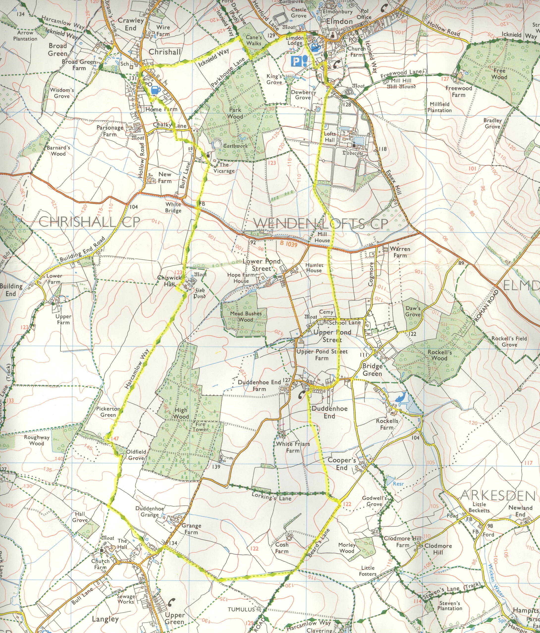
A walk from Chrishall
Before you walk this route, please be aware that there is an ongoing poisoning issue in the area between Chishall and Elmdon (early-mid February 2008). This was recently pointed out by one of my site visitors. To know more, click here. This is worth bearing in mind if you have dogs or children with you.
Description: A walk around the extreme north-west part of Essex (near the border with Cambridgeshire,) going through the highest point in Essex. The walking is generally easy.
OS Ref: TL451387
Length: 8 Miles approx.
Approximate time: 3-3½ hours.
Parking: Church-yard at Chrishall (some way out of Town. See above for OS Ref.)
Refreshments: None during walk.
The walk
The first part of the walk follows part of the Icknield Way. This is one of the oldest roads in England, and goes from Ivinghoe Beacon in Buckinghamshire to Knettishall Heath in Norfolk.
Start by leaving the church-yard in a north-westerly direction, crossing a stile. In the meadow which follows, keep to the left of a fence, to come to a stile. Cross it, then the road after. Walk through an enclosed path to the right edge of a field, going right. Cross a road then walk between two fields initially, then follow the path behind some houses. It curves left then right before coming to a lane (Hogs Lane.)
Turn right at a road, then right again at a memorial, following a footpath sign to walk into Loveday Close. Go to the left, then shortly afterwards, the footpath goes right between some houses. Go through a kissing gate, then keep to the left edge of a field to cross two stiles, to be on the right edge of a field. Aim for a point just inside the left of a wooded area (Cane's Wood.) Turn right just inside the wood. Follow this to a way-mark post, and then turn left onto a track. Follow this to a road, turning half-right to be on it (Heydon Lane.)
Walk to the outskirts of Elmdon, turning right shortly at a footpath sign (you could follow the road to Elmdon, turning right at a junction to see the village.) Cross a stile, then walk along the left edge of a garden. Cross another stile into an enclosed area, soon going down to another stile. Follow the left of a field, turning left at a gate onto a lane. Follow this to turn right at a road.
Just after "Elm House" on the right, take a path to the right. Walk along the left edge of a recreation ground, then through a kissing gate at the far side. Keep along an enclosed path, crossing a track after about 400 metres. Carry on for another 350 metres or so to come to a stile at the end of the enclosed section. Cross it, then soon after cross a bridge. Turn left, then follow the left edge of a field with a wooded area to the left. At the end of the wood, go across a track, and continue in a SSE direction, taking heed of a way-marker to turn right. Follow the path gently downhill to a road.
Turn right onto the road, then left shortly after to walk along a tree-lined path heading gently uphill. Keep along this path, which emerges from the trees after about 300 metres to be along the right edge of a field. The path emerges onto a road which we cross.
Follow a path the other side through the middle of a field, keeping ahead at a hedge to come to an enclosed section. On coming to a road, turn right and head into Duddenhoe End. Look out for a footpath signpost pointing left into a lane named Brooksies. Follow the lane, then at the end go through a small car parking area. Head right at this point to cross a stile at the opposite corner, following some way-markers. Walk to the left of a fence (keeping it on your right) for a short while. Cross a stile, then a plank bridge. Walk across the middle of a field in almost a due southerly direction (165-170 degrees!) Cross a plank bridge at a boundary, then another plank bridge shortly afterwards. Keep ahead to cross yet another plank bridge, then turn left at a lane (Lorking's Lane.)
At the end of Lorking's Lane, turn right into Beard's Lane. This is part of a Roman road. Where the lane goes right, keep ahead to follow a byway. Cross a ford further on, then soon after, follow a footpath way-marker to go right to join the Harcamlow Way. We'll be following this long-distance path for the rest of our ramble. Walk along the right edge of a field to its corner. Turn right at a way-marker, then follow a track for a few metres. Turn left into a field, then immediately right to follow its right edge. Cross a stile at the far side, then shortly after go through a kissing gate.
Turn left onto a road, and follow it into the outskirts of Langley. Turn right at a fairly recent housing estate (no signpost) and follow an unmade road, with a cricket ground to the left. Near the end of the road, venture onto a grassy area to the right, soon to find a way-marker indicating right. Follow it, then a few metres later look out to the left to follow the path. It becomes enclosed for a short way. Go across a meadow. Cross its boundary to walk along the right edge of a field. At a way-mark post, go right to follow the right edge of a field. The edge snakes right and left for a while, before coming to another way-mark post.
At this point it is worth mentioning that you are at the highest point in Essex at 147 metres (Oldfield Grove.) It may not seem a high spot, but there are, however, some fine views to the south-west.
Go right through a small section of woodland, soon emerging from it into a field, after crossing a rather dodgy plank bridge then going through the gap in a fence. Keep along the left edge of this field. The church at Chrishall soon appears, as does Chiswick Hall.
This section is a pleasant part of our walk, with the church nearly always in the background. Follow the path as it goes across a field, with some good views to the north and west, with woodland to the east. After coming to Chiswick Hall, follow some way-markers to go first left, then right, going between the main buildings to the right, and some paddocks and a tennis court to the left. Join the path at the front of the house, then follow it to a road.
Turn left, then very shortly right. Cross a bridge to walk gently uphill to the church. There are some good views to the south from the church.
This brings you back to the start of the walk.
Click here to get an OS map with the route highlighted.
|
|