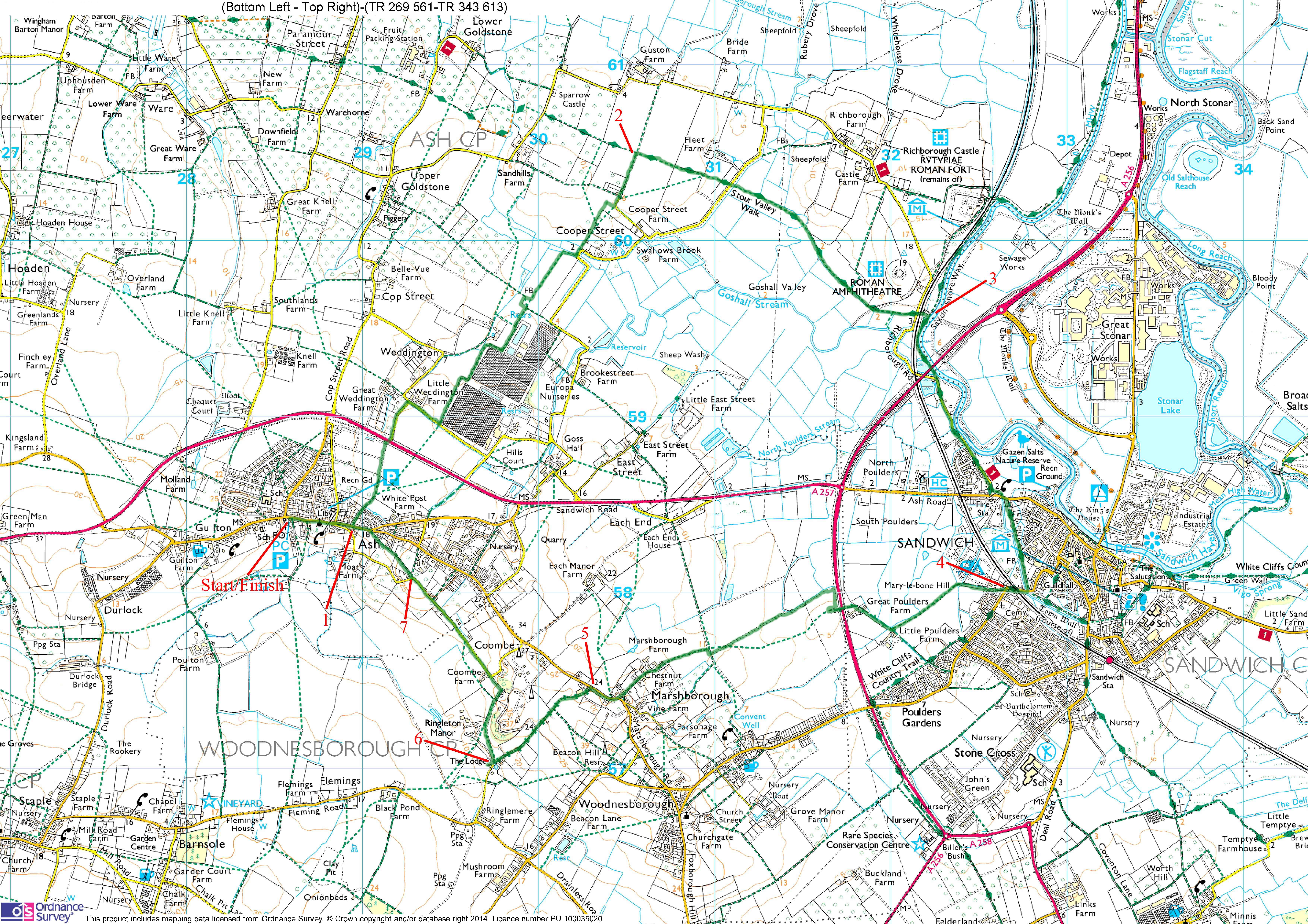
Ash, Sandwich and Marshborough
OS Ref: TR285583
Length: 8 miles
Approximate time: 2½ 3 hours
Parking: Free car park in Ash, opposite the Co-op
Refreshments: Pubs in Ash and Sandwich
An undemanding circular walk from Ash, taking in the delightful town of Sandwich. The walk passes a Roman Amphitheatre, then follows the river Stour, before starting its return leg.
Black-spots:
1 The byway to the west of Marshborough (between TR300573 and TR297570) can be really muddy after rain. It is worth wearing wellingtons for the walk if the weather has been predominantly rainy, even if it's just for this section!
2 The path on the east boundary of Ringleton Manor can be awkward for footing.
The walk
Turn right out of the car park and walk about 400 metres until you come to a footpath on the left, which follows Burford's Alley (1). Walk along this path, with a house to the right initially, becoming a wall. Pass some allotments soon on the left. Turn slightly left when the path comes to a field and follow the left edge of the field, with a rugby field the other side of a fence.
Cross the busy Ash bypass road and walk along Weddington Lane in the same (NNE) direction. Turn right at the end of the lane and walk about 150 metres until you come to a pair of public footpath signposts. Follow the left one to walk along the right edge of a field with a nursery to your right, the other side of a fence. The path deviates right then left (twice), to come to some posts at the far end of a field. Continue along the right side of the next field near the corner, turn left onto the adjacent field, then right for a few paces, then turn left to walk across the middle of another field. The OS map shows a footbridge here, but it's non-existent!
Go though a gate, then cross a bridge at the far side of this field, turning right just afterwards. Turn left at a public footpath signpost onto a road. Keep ahead at Little Clevelands, following another footpath signpost to leave the road. Walk to the left of a hedge, along the right edge of a field (don't follow the drive), soon to go through a gap to the right. Walk along the left side of an orchard. The OS map shows the path cutting through the trees here, but that's not always possible keep to the left of them to come to a tee-junction at the far side. Turn right here for a few paces, then left onto a track at a footpath sign. Pass to the right of a couple of houses and go straight ahead, with a hedge to the left initially.
Turn right at a waymark post (2) to join the Stour Valley Walk. Go through a gap into the next field to walk along the left edge of it, crossing the next two fields before coming to a lane, crossing a bridge either side of it. Walk across the middle of the next field, crossing a bridge over a stream at the far side. Walk along the right edge of three pastures separated by gates, crossing a board-walk near the end of the second. On the third pasture, the remains of a Roman amphitheatre can be seen to the left (just a mound from this angle).
Go through another gate at the corner of the pasture into an enclosed area, walking through a copse, keeping ahead at a waymarker. On emerging from this wooded area, look for some signposts near a gate, which notify you of a pedestrian railway crossing. Make for these signposts and go through a kissing gate to the right of the main gate. Cross a road, cross a stile, cross the railway then another stile. Keep ahead until you come to the River Stour. Turn right and follow the river (3), passing underneath the ever-busy A256.
The route by the river is short-lived, as you soon bear left onto a road at the end of the path. Carry on into Sandwich. Turn left just before a fire station to follow a path, punctuated by a signpost. Turn right to cross the road at a footpath signpost, bearing a finger with Saxon Shore Way upon it. Walk along a footpath called The Butts, following part of the old town wall. You may want to have a wander round the delightful town before moving on, one of the Cinque Ports.
Follow the path slightly right further on, to walk to the left of an area of scrub. Later on, there's a cricket pitch to the right, the other side of a stream. At the end of this path, turn right onto Woodnesborough Road. Pass a railway level crossing, then where the road bends left, carry on in the same direction, heading for Sandwich Leisure Park. Where the road bends right, leave it on the left through a gate (4). Follow a path immediately to the right, staying near the perimeter of the park home site. Cross a footbridge soon, still following he border of the park, then another footbridge soon-after.
Keep along a grassy path between two fields a ditch soon appears to the right. Follow the ditch to a lane, turning right to walk in a NW direction. Pass some paddocks and stables on the left, to walk along a concrete part of the lane. Cross the A256, turning sharp right the other side, doubling back on yourself, to follow the edge of a field. Turn left at its corner to walk in a WSW direction for about 800 metres, passing a pylon.
At a tee-junction, turn right for a few paces, then left to resume your WSW direction. Pass some farm buildings, eventually coming to Marshborough Road. Turn right here to follow the road for about 200 metres. On coming to a byway signpost on the right, follow it left (5) to go past Green Gables. Go through a gate and walk to the left of a farmyard. Keep ahead where a path joins from the left this signals an approaching turn which can easily be missed! The byway soon dives right and becomes sunken for a while. It can be really muddy here after rain. If the weather has been wet for some while, it is worth wearing Wellington boots just for this section!
At the end of the byway, by the entrance to Ringleton Manor, turn right crossing a stile (6), to follow an enclosed path. The footing can be quite treacherous here, as there is only a narrow area to walk on the path seems to have a rather steep Vee shape to it!
Ignore the turning to the left, which may seem the obvious (but awkward) way to go, but carry on until the path comes to a T-junction with a track, turning left onto it. The track soon gives way to a road which appears from the right. Follow the road in the same (NW) direction for about 800 metres.
Where the road bends left at Mill Croft leave it (7) to follow a footpath signpost. Walk diagonally through a small parking area to pass a brick wall, turning half-left after it. Walk along the right edge of an area of scrub, the path soon becoming enclosed. Go through a kissing gate to walk along the right edge of another area of scrub. Go through another kissing gate (don't follow the path round to the left). Keep along the right side of a meadow going through another kissing gate, turning left onto The Street. Keep along The Street to arrive at the car park you started from, on the left.
Click here to get an OS map with the route highlighted.
Click here to get a GPX file to load into your GPS gadget.
|
|