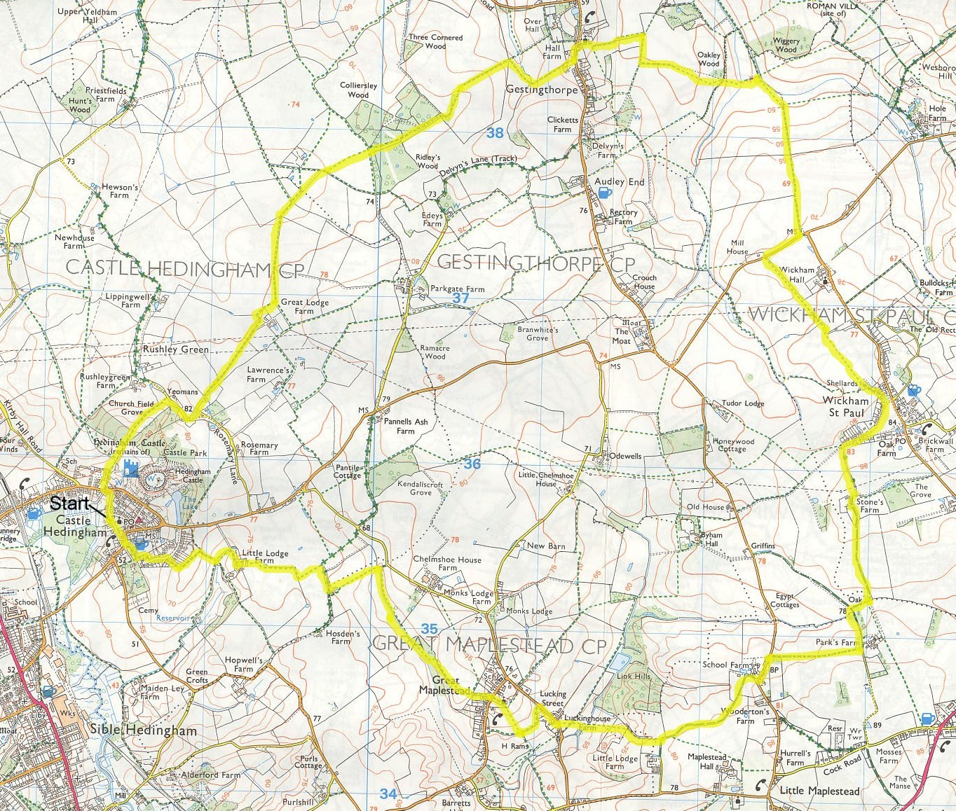
A walk around Castle Hedingham, Gestingthorpe and Great Maplestead
Description: A generally easy walk through some of the countryside of north-west Essex. Astonishingly, there are only a few points during the walk where you can see the local landmark of Hedingham Castle! Hedingham Castle's Norman keep, 110 feet high, was built c.1140 by Aubrey de Vere and is still owned by one of his descendants, The Honourable Thomas Lindsay and his wife Virginia.
OS Ref: TL785356
Length: 10¼ Miles approx.
Approximate time: 3¾ - 4½ hours.
Parking: Street parking in Castle Hedingham.
Refreshments: Pubs in Castle Hedingham.
The walk
Start on the road to the west of the church (Church Lane) in a northerly direction. Continue in this direction along Crown Street, until you come to a road. Head slightly left the other side of the road to follow a signpost just to the right of Pye Cottage. Walk through a wooded area, to keep ahead at a way-marker (not left.) Cross a stile, and head gently uphill on a meadow. There are some glimpses of Hedingham Castle to the right. Cross another stile at the top (pretty rickety at the time of writing,) and turn right onto a lane.
The lane goes left just after Keepers Cottages on the right. Walk past Rushley Green then turn left. Follow the lane; just past a double garage the lane goes right. Continue along the lane to bear left at a way-marker, just after walking under two power lines. Follow the right edge of the field you are now on, to do a quick left-right in succession, passing a tennis court shortly after.
Follow the next few way-markers, in a northerly, then NNE direction, until you get to one with "FP12 across field" marked on it. Follow it across a field, cross a plank bridge then enter a wooded area (Ridley's Wood.) Follow the path through this wood, to the left of a clear area initially. At the other side of the wood, the path goes slightly right before you're directed left by a way-marker. Gestingthorpe can be seen from here, and is our next destination.
Follow the left edge of the field you now find yourself on, which soon becomes a track. Follow the track right, then left and continue to a road. Go through a gate and turn left onto the road. After a few steps, there is an idyllic scene, first of an old water pump on the opposite side of the road. A bit further, then there's the view of a thatched cottage, with the church rising behind it. Gestingthorpe church is typical of quite a few in this area - certainly its brick tower.
Turn right at a footpath sign just before the church. Follow the path first right, then left to walk round an enclosure. After going past the enclosure, carry on along the right edge of the left field. Turn right at the junction with another path, by two small power line posts (no way-marker.) Carry on to the corner of the left field, then turn left (again, no way-marker.)
At a copse, follow its right edge then take heed of a way-marker to cross the next field. Turn half-left at the next boundary, to follow the path to a bridge. Turn right just before the bridge to follow the left edge of a field. Turn slightly right a short distance after to walk gently uphill on a track, eventually coming to a road.
Turn right on the road and follow it for about 300 metres. Turn left at a footpath signpost to be on a path on the left of a field. Follow this path, which loses its hedgerow on the left after a short while. On the left at this point is the church of Wickham St Paul (another fine brick tower!) Keep ahead to walk under a power line. Cross a bridge on the far side of the field to be on the left edge of the next field. At an unmarked way-marker (at the time of writing) carry on in the same direction across the field to the other side. Follow two more unmarked way-markers to come to the outskirts of Wickham St Paul.
Follow the path as it becomes a track, then a full tarmac road. Turn right at a tee-junction with a more major road, then walk in the direction of this road for about 300 metres. At this point, the road goes left, through a couple of brick pillars, with a "Stones Farm" sign covering three of its brick courses on the left. Keep along the road (now more of a lane) to come to a junction with a footpath signpost, and a bridleway signpost. Follow the bridleway sign to the right, going to the left of buildings. Keep on the lane (soon to become more of a track!!)
The bridleway diverts to the left of the track for about 200 metres, then rejoins the (now concrete) track just before a threadbare wind-sock on the left. The track continues, soon to have a right-left dog-leg in it, going past a way-marker. Don't stay on the track here however, but turn right to follow a bridleway way-marker just before a paddock. After a short while, follow another way-marker to go left through a wooded area, which soon opens up, with more paddocks to the right.
Shortly, you'll arrive at a signpost (pointing in the direction you've just come from,) with a way-marker beside it. Follow the red arrow painted on the way-marker to go right on a footpath. Go through a metal kissing gate, then walk in a westerly direction for about 600 metres. The path becomes concreted for a short way before coming to a road.
Turn left onto the road and follow it for a brief while. At a left bend in the road, (soon after an entrance to School Farm) go right in the direction pointed to by a bridleway signpost. Keep in this direction before turning left to follow the bridleway through an enclosed section. This can be typically muddy (as can a lot of bridleways,) especially in the narrower parts.
Eventually, after a few gentle twists and turns, the bridleway opens up to be on the left edge of a field. Keep on along this edge, with the tower of the church at Great Maplestead coming into view on the right after a short while. After a path joins from the left, with its associated way-marker, there's another way-marker very soon afterwards. Follow the yellow footpath sign on this to go to the left of a gate, then walk along an enclosed path to the left of a field, descending after a while.
Go through a gate (more of a sort of barrier affair at the time of writing!) Head slightly left to go through a gap in the corner of a field. Walk diagonally across this field to a point slightly left, of the left of two isolated trees on the far boundary (the logic sounds a bit convoluted, but it's fairly obvious!) Carry on after the boundary in the same direction, going through a gap in the next boundary. Aim for a peach coloured house, with two gable ends towards you. Go through a gate and turn right onto a road.
Walk about 200 metres along the road before turning left at a signpost. Follow the left edge of a field, then turn right at a way-marker to ascend the field towards Great Maplestead church (the first church on our walk without a brick tower!) Follow the path through the churchyard, go out the gate then follow a signpost on the opposite side of the road to carry on in the same direction.
After walking between some properties, follow a way-marker to go straight ahead across a field. Take heed of the next way-marker you come to, to bear right and follow the left edge of a field. Be sure not to miss a left turn in about 300 metres time! When I was doing a feasibility "reconnaissance study" for this walk, I completely missed this turn, and re-traced my steps to go via some local roads instead (silly me!!)
Anyway, go down some steps, cross a plank bridge, walk through a few metres of undergrowth then turn right. Follow the right edge of some meadow-land, not to be tempted left at a plank bridge! At the time of writing, there was a tree which had been brought down by recent storms. I guess it will be there for some while as it's in an awkward spot to extricate it.
Take a diversion to the right of this tree. A few metres on, there is a bridge. Cross it then follow the left edge of the field after. At the far corner of this field, look out for a stile (I imagine this can be hard to spot if it's overgrown.) Cross it and follow the left edge of a meadow. At the far end of the meadow, cross a stile then go immediately left. Follow the path on the right edge of a field for a brief spell, then follow a way-marker to go across a field.
Aim to the left of some houses the other side of this field. It can be a bit treacherous here, as the path across this field is not well defined or well kept. At the far side, walk along a grass verge in the same direction to come to a track. Turn right along the track. This is only the second point during this walk that you can see Hedingham Castle (or the flag at the top anyway!) After a short distance the track goes right. At this point turn left along a footpath in a WSW direction. Turn right at the next boundary, then left shortly after to follow the right edge of a field.
Just before some farm buildings, follow a way-marker to turn right, then go left at another way-marker to dive through the hedgerow. Go through a farmyard to come to a track. Turn right and follow this track until you come to a way-marker next to a stile on the left. Cross the stile then follow the right edge of a field (well - not the extreme right to start with maybe - you'll see what I mean!) Follow the path to the far right corner, then cross a stile (leaning over pretty precariously at the time of writing.)
Go ahead to the left of a tree to walk gently uphill across a field. Here, you get the first decent view of Hedingham Castle. At the far side of the field go left at a way-marker. Take heed of the next way-marker to go half-right. Keep along the edge of the field, ignoring the first possible right turn, soon to go right at a corner of the field, thus walking downwards to Castle Hedingham. Soon you'll be met with the best view of the Castle yet.
Turn left on coming to a road. Follow the road until you come to an alley on the right (just after a hedge.) Go down the alley, turning left after a few metres. Follow the alley until you come to some steps on the right. Turn right to go down these steps (nice view of the church,) then downhill into the Town "proper".
Turn left at the end of the alley, onto a stone path (Pottery Lane.) Turn right at the end of Pottery Lane on to Queen Street. Follow Queen Street into King Street. Keep ahead to arrive at Castle Hedingham church, from where the walk started.
Click here to get an OS map with the route highlighted
|
|